A storm system will bring snow to the area Monday afternoon-Tuesday morning.
Melting of the snow today has allowed for the soil to show. This in turn has allowed the temps to rise to near 40.
Monday: A mostly clear evening will lead to cold temps Monday morning. Temps will most likely be in the single digits. I would say below 0, but the day has been a little too warm to forecast that. Clouds will begin to build in during the morning hours resulting in a cloudy sky by 8 or 9a.m. Temps will rise in the afternoon to around 30. Snow will start as early as 1p.m. with accumulating snow beginning after 3p.m. Snow will pick up in intensity during the evening hours. The heaviest snow looks to come down between midnight and 4a.m. Given temps in the upper 20s overnight, snow will be wet which means you can pack it. Winds will from the S to SW at 10-15mph with gusts to near 30mph between Monday and Tuesday morning. This will cause snow to drift across roadways making them ice covered. Travel Monday night and Tuesday morning look to be icy. I will update as new information comes in.....
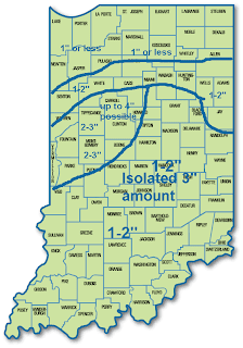
Snowfall Prediction for Indiana Monday afternoon- Tuesday Morning
There will be a small 2-3" band that moves over our area. A rain snow mix is possible for far southern Indiana and less than an inch of snow can be expected for far northern Indiana where the least amount of moisture will be.

No comments:
Post a Comment