Wednesday, August 8, 2012

Severe Weather Threat for Thursday August 9th


A strong cold front will move through sometime Thursday late afternoon/evening or early Friday morning. This will bring a chance for damaging winds and large hail. I don't think there will be a tornado threat, but I will update if there is one. There isn't a high enough helicity to warrant a tornado risk. All the below ingredients are good for a multicell or linear storm mode. A few super cells can't be ruled out with the wind shear.

CAPE values will be moderate/high. Surface CAPE values over 4000J/Kg seem likely. This is more than enough to fuel severe thunderstorms.

Dew points will also be very high. Dew points in the low 70s appear likely with the potential for dew points in the mid 70s!! This along with temps near 90 will produce a muggy day.
With this shear in place, a few super cells are possible. The overall storm mode will be multicell then transition to a more linear mode later in the evening.


The Storm Prediction Center has placed most of Indiana in a 30% chance for severe weather tomorrow. Central Indiana will see the best chance for severe weather. Again, the main threats will be damaging winds and large hail.


Friday, August 3, 2012

Severe Threat for August 4th

The Storm Prediction Center has issued a slight risk for Severe Storms for parts of Indiana, which includes a line from Attica to Lafayette to Ft. Wayne. These storm will be capable of producing damaging winds and large hail. An isolated tornado is also possible with these storms.
 
These storms will be possible thanks to a cold front moving through the area. You may ask how I or meteorologists know where a cold front is at a given time. I have made a few situations based on tomorrrow's set up to show you a few ways/tricks.
 Storms need good instability and tomorrow will have more than enough....
Instability goes hand in hand with temps and dew points. Saturday will have high temperatures and high dew points. This will also lead to high heat index values. Heat indices will be at or exceed 110 in the western part of the state.

Another good ingredient to have for severe weather is high wind shear. We will have a decent amount of shear, but exceptional low-level winds.
Helicity is the amount of rotation in the atmosphere. There will be some, but not enough to call for multiple tornadoes. However, an isolated tornado is possible.
After analyzing all the data this is my prediction for severe weather as it stands now for tomorrow. I will have better grip for timing tomorrow morning. I am thinking late afternoon or early evening.

Thursday, July 19, 2012

Severe Storm Possibility Today

Sunshine will come out today to destabilize the atmosphere.
Storms will initiate in the early afternoon hours.

Wind shear looks good for strong to severe storms today.

Given some helicity, an isolated tornado is possible, but not likely.

Downdrafts will be the main form of severe weather today.

CAPE values are more than enough to sustain severe storms.
Temps will rise in the afternoon into the upper 80s-low90s (90). Storms will bubble up in the afternoon thanks to day time heating and an incoming cold front. The main threats will be large hail and damaging winds. An isolated tornado is also possible in the afternoon.

Thursday, June 14, 2012

Brush Fire Danger: Extremely High

Due to our dry spell, conditions are prime for brush fires to get started. There have been numerous brush fires from around the state. One in Shelby County closed I-74 for a few hours. There is another brush fire in Tippecanoe county near Buck Creek and Lafayette.

Conditions are very favorable for brush fires to develop. Be careful if you have a fire or are a smoker. Cigarettes have caused a few brush fires.

Wednesday, June 13, 2012

Tomorrow

Thursday: It is going to be another dry and mostly sunny day tomorrow. The day will start with temperatures in the low 50s (51) and will soar in the afternoon into the mid 80s. (86) Winds will be light from the East shifting from the South East in the afternoon at 5-10mph. Temps overnight will cool into upper 50s to low 60s.

Monday, June 11, 2012

Severe Threat For Today

Today: It is currently a muggy 80º here at the house. We are on our way to a high of 90º later today. Due to the front slowing a little, thunderstorms will be here in the afternoon instead of the morning. This will allow for more destabilization in the atmosphere with the heating of the day. I expect storms to arrive in the area anytime between 2-8 today. Below are current scenarios of the weather right now. The severe storm threat for today is pretty marginal.


 The main threats with any storms that can be severe today will be gusty winds and large hail.

Friday, June 8, 2012

Today's Forecast

Today: It is another dry hot day. It is currently 83. The high for today was 89. Dewpoints are currently in the low to mid 40s and humidity is in the mid 20%. This in turn allows for an elevated fire danger for this afternoon. Winds will remain light at 5-10mph. A high pressure center is responsible for the mostly clear sky and light winds. The high pressure center is located in Southern Indiana. Thanks to the desert-like air mass, temps will fall rapidly this evening. We will see mid 70s by 8 and mid 60s by mid night. It will remain clear for the evening hours.

Week ahead (June 9-16): Temps will be in the 90s for tomorrow, Sunday, and possibly Monday. Late Sunday-Early Tuesday show rain and thunderstorms. Storms will start up Sunday evening, these storms look pulsey in nature, which means they will peak in intensity very quickly and fade away just as fast. The main line of storms will move through Monday evening. There appears to be enough  moderate wind shear and moderate CAPE or instability for isolated severe storms to develop. I will keep an eye on what new data says in the coming days. After that, it will be dry through June 20. Temps will be cooler neat week with temps ranging from the mid-upper 70s to the mid 80s.

Tropical Update: I'm not an expert at tropical weather, but I will give it a whirl. There appears to be a tropical storm that will impact the East coast June 19-21. The models keep it just off the coast, but it has the potential to make landfall in the North Carolina area. Winds with this storm are projected to be 40-55mph. It is possible however that this storm may be a hurricane. We will have to wait and see.

Wednesday, June 6, 2012

Today's Forecast

Wednesday: The temperature is currently 68º under clear skies. Expect some clouds, more specifically cumulus clouds,  to bubble up in the afternoon as our high temperature maxes out around 80º (80). I will go for a partly cloudy-mostly cloudy sky for the afternoon hours. It will be very similar to yesterday. Winds will be 5-10mph with an occasional gust to 15mph. As night falls, clouds will tend to burn off, but a few may still remain. Temps during the evening hours will fall into the upper 50s. (59 around midnight)

Week Ahead: Conditions will remain dry through Monday with 90s likely for the weekend. The weekend will also feature higher dew points and humidity making the air stickier.

Tuesday, June 5, 2012

Today's Forecast

Tuesday: Skies will remain sunny with a cloud here and there in the afternoon. A widely isolated shower is possible in the afternoon, but chance of precip. is 15%. Temps will top out in the mid to upper 70s (77). Winds will be from the N at 15-20mph with gusts as high as 25mph. As night falls, a couple will clouds will linger. Temps will be in the mid 60s for the evening hours.

The week ahead: Temps will gradually rise through the week, We will see the 80s by Thursday (possibly tomorrow) and the 90s will return by Sunday. The next best chance for rain is Tuesday. It looks like a line of storms will move through the area. It appears a severe threat may exist for Tuesday. I will keep an eye on it and see if the severe weather threat will hold up for next Tuesday.

Monday, June 4, 2012

Today's Forecast

Today: Clouds will gradually decrease through the afternoon. Rain showers will also continue until the cloud deck moves away. Temps will rise into the upper 70s to near 80 as clouds decrease (77). Winds will be 8-14mph with gusts as high as 21mph. As night falls, skies will be mostly clear with temps in the mid to upper 50s.

Wednesday, May 23, 2012

Thursday Forecast

Thursday: Tomorrow will feature mostly sunny skies and warm temperatures. The day will start clear and temps in the upper 50s (58). Mostly sunny skies will dominate the day as the temp rapidly increases. The temperature will max out in the low 90s (91). Winds will be 17-24mph with gusts as high as  35mph.  A few low clouds may bleed in towards nightfall. Temps will be in the mid-low70s during the overnight hours.

We will see the 90s this weekend through Monday. We may see temps in the mid 90s this weekend with heat indices well over 100º. Also, a chance for thunderstorms exists Friday afternoon. A marginal chance for severe weather exists for Monday afternoon-evening. I will post more on the potential for severe weather in the coming days. The main threats appear to be large hail and strong winds.

Tuesday, May 15, 2012

Wednesday Forecast

A few showers and thunderstorms are possible during the evening hours. These storms will not be severe, but an isolated wind gust of 40-50mph can't be ruled out.

Wednesday: Wednesday will be very similar to today in the sense of how dry it will be. The day will start in the mid 50s under partly cloudy skies. These clouds will diminish in the afternoon to a mostly sunny sky. The temperature will warm rapidly in the afternoon into the upper 70s to near 80. Winds will be 13-18mph with an occasional gust near 25mph. As nigh falls, skies will become clear. This combined with desert-like air will cool the air quickly. Temps during the evening hours will fall into the low-mid 50s by midnight.

Saturday, May 12, 2012

Mother's Day Forecast

Sunday: The day will start in the mid 50s. A mix of clouds and sun are likely for the day tomorrow. Temps will likely reach the mid 70s, but some models want the temp to near 80. Not really sure on this idea because of a cold front near our area. Temps in the mid-upper 70s will bubble up a few storms in the afternoon. These showers/ storms will be isolated. Winds will be 10-15mph with an occasional gust over 20mph. As night falls, these showers will diminish skies will gradually become partly cloudy. Temps during the evening hours will fall into the mid 50s.

Sunday, April 22, 2012

Monday Forecast

Monday Forecast: The day will start cold with temps near 30. A few clouds will be around, but it will be partly cloudy overall with a lot of sun shine. Temps will rise in the afternoon into the mid-upper 50s. It will also be windy with winds at 20-25mph with gusts up to 35mph. As night falls, a mostly clear sky can be expected. This will allow temps to fall rapidly. Temps will be in the mid-upper 30s by midnight.

Friday, April 20, 2012

Cold Front Approaching

Rain showers will begin to overspread the area beginning between 1-2. A few rumbles of thunder are possible in this line of showers.

Thursday, April 19, 2012

Friday Forecast

Friday Forecast: Rain showers will impact the morning through early-mid afternoon. Given some instability a few rumbles of thunder seem possible. Temps will start the day decent in the mid 50s. Temps will rise rapidly ahead of a cold front to near 70. After the cold front passes early-mid afternoon, temps will fall rapidly. Winds during the day will be 10-15mph with gusts up to 25-30mph. Rain will end late afternoon to early evening with skies gradually clearing. These clearing skies will allow for the temp to drop. Temps will likely drop to near 40 by midnight Friday night. Temps in the low-mid 30s will allow for some frost to develop. Our golf match for Saturday morning may be delayed because of frost.

Wednesday, April 18, 2012

Thursday Forecast

I finally have time to do a forecast!!

Thursday: The day will start rather warm with a temp near 50. Clouds will be around for the morning and most of the afternoon before partial clearing late afternoon- early evening.  Temps will rise nicely in the afternoon into the upper 70s to possibly near 80 (79). Winds will be at 12-18mph with gusts as high as 30mph. As evening settles in, partial clearing is possible. Temps will hold in the low-mid 60s for the evening hours. The rain/t'storms will hold off until Friday morning-afternoon.

Monday, April 16, 2012

Monday Forecast

Monday: Temps will only rise a few degrees from this morning today to a high near 65. A mostly-partly sky will dominate the sky today with predominate low level clouds around. Winds will be gusty at 25-33mph with gusts near 50mph. Overnight, a few clouds will be around with temps falling rapidly into the mid to upper 40s.

A weekend in review: A deadly tornado outbreak took place Saturday evening with at least 5 confirmed fatalities. A tornado also went by my campus of Oklahoma University. I am so excited to go next year. Over 130 tornadoes were reported. I will have the exact number a little later. If I have time, I will have a breakdown of what happened and what the mechanics were.

Tuesday, April 10, 2012

Wednesday Forecast

Wednesday: The day will start cold with temps near 30. A freeze watch is in effect right now. I wouldn't be surprised if we are upgraded to a freeze warning sometime later today. Skies will be partly cloudy in the morning. As the day progresses a few low clouds will hang on, but overall it will be mostly sunny. The temp will rise in the afternoon and peak near 54. Winds will also be calmer at 10-15mph with an occasional gust near 20mph. As night falls, a few low clouds will hang around with temps falling into the mid-upper 30s. Given humidity values in the mid 30%s  and some wind, a fire threat will exist, however, it will be much lower than Monday and Tuesday.

Update to Tuesday's Forecast

The only thing I want to change is the temp. Today's high is going to struggle to get into the low 50s. It is going to be chilly so plan accordingly.

Monday, April 9, 2012

Tuesday Forecast

Tuesday: We will see a taste of winter for the next 3 mornings. Temps tomorrow morning will be near freezing at 33. We will see temps in the upper 20s come Wednesday morning and possibly Thursday morning. If you have any sensitive plants, be sure to cover them by Wednesday morning and Thursday morning. The atmosphere will be dry along with the ground, add in wind gusts near 35mph and you have an elevated fire threat for tomorrow.  The skies will start clear, but some low clouds will increase through the day from the north. Highs will only be in the mid 50s. Winds will also be gusty at 15-20mph with gusts as high as 35 mph. The evening will be partly-mostly clouds with temps in the upper 30s. Temps by Wednesday morning will be in the upper 20s!!

Sunday, April 8, 2012

Monday Forecast

Monday: A few showers are possible Monday morning, otherwise skies will start the day cloudy with temps in the low-mid 40s. Some partial clearing will occur in the early afternoon, but the afternoon will have partly-mostly cloudy skies. Temps in the afternoon will rise into the mid 60s. Winds will be gusty in the afternoon at 20-25mph with gusts as high as 45 to even 50mph. With relative humidity dropping into the middle 30s, dew points dropping into the 30s, and strong winds, an elevated fire danger seems likely tomorrow. I wouldn't be surprised if a fire weather watch was issued tomorrow afternoon. The clouds will allow for the dew point to stay above critical fire danger levels (clouds help moisten the atmosphere). As night falls, skies will clear with the exception of a few high clouds. Temps will be in the mid 40s during the evening hours.

Mushroom Update: Dad and I found the largest mushroom so far this year today. It was as round as a pop can and about a half inch taller. All in all, we found 94 yellows today with over half being taller than 3".  Not too bad of a find.

Friday, April 6, 2012

Saturday Forecast

Saturday: Saturday will start cool with temps in the mid 30s. These temps and light winds will allow for some frost to develop. Clear skies will dominate the morning and the afternoon. Temps will shoot up in the afternoon into the mid-upper 60s. Winds will be fairly light at 5-10 mph with an occasional gust near 20mph. As night falls, clouds will increase. Rain is possible late Saturday night. Less than .1" is expected at the moment. Temps will be in the mid 40s during the evening hours.

Monday, April 2, 2012

Monday Forecast

Monday: After a morning low of 51 skies stay mostly sunny with a high in the low 70s. Winds will be 15-20mph with gusts near 35mph. Overnight will see clouds increasing from the north. A stray thunderstorm is possible late tonight. Temps will be in the mid 50s. There is a marginal chance for severe weather tonight with the main threat being hail. Tomorrow will also see a marginal severe weather threat. I will update if there is a change to the severe weather threat this evening.

Mushroom Update: After finding 120 yellows yesterday, our total has increased to 320. I forgot to update other finds earlier in the week. Morel season is in full stride right now. If you like to hunt them, get out and find them. The upcoming week looks nice.

Friday, March 30, 2012

Friday Forecast

Friday: Today is looking really warm. Temps this morning will be around 50. Temps will rapidly rise in the afternoon to near 80. Winds will be 15-20mph with gusts near 40. Thunderstorms are possible this afternoon. Some of these thunderstorms may be severe (more below). Thunderstorms will move through the area tonight. Temps will fall into the mid 40s by mid night tonight..

Severe Weather Threat This Afternoon: There is a threat for severe thunderstorms later this afternoon and evening. Based on the latest model runs, thunderstorms will begin to impact our area between 3-6 this afternoon.Thunderstorm initiation looks to be as early as 2 and as late as 4. The earlier the initiation, the more time the storms have to obtain energy. CAPE (instability) values will range from 1000-2000J/Kg. A decent amount of wind shear will be in place later this afternoon. This will allow for rotating storms or super cells to develop. This will heighten the risk for large hail and an isolated tornado. I will update on the severe weather threat when I can. The Storm Prediction Center has us under a SLIGHT risk area today with a 15% chance for large hail and damaging winds and a 2% chance of a tornado within 25 miles (very small). South Eastern Indiana has a 30% chance for large hail and damaging winds and a 5% chance of a tornado with 25 miles of a point. The next update from the Storm Prediction Center is 12:30. I will update if they and the new model runs have new information.

Tuesday, March 27, 2012

Severe Threat for Tonight...Wednesday Forecast

The Storm Prediction Center out of Norman, Oklahoma has issued a Slight risk area of severe weather for our area this evening. The main threats will be large hail and damaging winds. The threat for a tornado is 2% which is pretty small. Thunderstorms are developing in western Illinois right now. Storms will roll through late tonight-early tomorrow morning. Severe storms are possible around or a little after midnight tonight.

Wednesday: The day will start warm in the mid 50s. Clouds will clear as the day progresses with a few clouds hanging on in the afternoon. Temps will rise into the mid 70s. Winds will be gusty at 15-20mph with gusts near 40mph. As night falls, skies will be clear which will allow the temps to fall rapidly. Also, low dew points will help the temp fall fast. Temps will be in the mid 40s by midnight and the upper 30s by the following morning.

Monday, March 26, 2012

Updates to today's forecast and Tuesday's Forecast

Today: A few showers are possible through early afternoon. I will forecast a 30% chance for a light shower. I still expect temps to top out near 60, but we may end up a degree or 2 short.

Tuesday: A few clouds will be around for the morning. The mostly clear night will allow for temps to be in the mid 30s Tuesday warning. A frost advisory is in effect for Tuesday morning through 10a.m. A freeze warning is in effect for Lafayette eastward. The frost/freeze warnings have the potential to kill off newly budded vegetation. If you have flowers or any other vegetation susceptible to freezing temperatures, cover them up tonight. As the day moves forward, skies will clear out. This will allow for the temperature to soar into the low 70s. Winds will be 10-15mph with gusts near 30mph toward evening. Clouds will increase during the evening hours. A line of showers and thunderstorms will pass late Tuesday-Early Wednesday morning. Moderate CAPE (or instability) decent wind shear, moderate Helicity (spinning in the atmosphere), and dew points near 60 will allow for some severe storms to develop. New model runs are suggesting that severe storms will have enough "ingredients" to affect the area. I will have a better idea later this evening. At the moment, large hail, damaging winds, and an isolated weak tornado appear to be the main threats. Temps during the evening will hold near 60.

Sunday, March 25, 2012

Monday Forecast

Monday: Clouds will start the day and will stick around all day. No rain is expected at this time. Temps will start the day much cooler than what they have been. (right around 40) Clouds will inhibit a decent warm up for the afternoon, but expect temps to top out near 60.Winds will be from the Northeast at 10-15mph with gusts up to 30mph. Clouds will stick around for the evening hours with temps dropping to near 40. Tuesday morning may see temps near freezing.

Mushroom Update: The total is now up to 127 after finding 49 mushrooms today. The yellows/grays are coming along. The morels should really be up by next weekend barring any freeze that may occur.

Saturday, March 24, 2012

Saturday Forecast

Today: A nice day is in store for today. The temp is already near 70. I am going to forecast a high of 73 today (this number may be a little conservative). A few thunderstorms are possible today as the low spins through the ohio river. Winds will be light today with "gusts" only reaching 10mph. Enjoy the day!!

Morel Update: Dad and I went out this morning and took home 28 black morels. This brings the season total up to 76 morels. We also found our first yellow and gray morels today. We found a total of 9, but we left them to grow and were not counted into the total above. I have a feeling tomorrow will be a good day to look.

Friday, March 23, 2012

Friday Forecast...........Chances for Severe Weather

A thunderstorm watch has been issued for South-western Indiana and Southern Illinois. I expect a thunderstorm watch to be issued for our area later today. The main threats will be large hail, wind gusts up to 60mph, and an isolated weak tornado.

The chances for severe weather are thanks to an incoming cold front associated with a strong low pressure system. Also, temp in the mid 70s and dew points in the 60s will allow for an unstable air mass. Also, the upper low has a cold pocket which will allow for towering cumulus clouds to develop. Wind shear is also more than sufficient to allow for super cells to form.

Currently: We are in between 2 waves of rain. This will allow for some sun to show for the next few hours. This will warm our temps into the mid 70s. Rain/thunderstorms will start up again after 4.

Tuesday, March 20, 2012

Wednesday Forecast

Wednesday: The morning will again be warm with temps in the low-mid 60s. Scattered cumulus clouds will be around all day. Rain chances are very small for tomorrow. Winds will be 10-15 mph with an occasional gust near 30mph. Temps will again top out in the mid 80s. Don't rule out temps in the upper 80s if enough sun can make it through. This again will set a new record which is currently 83 set in 1907. As night falls, clouds will gradually increase ahead of a storm system that will impact our area Thursday afternoon. Temps will stay in the upper 60s to near 70.

Morel Update: Found 8 morels today. All black sponge. After the rain Thursday evening and Friday, they should come up really well.

Monday, March 19, 2012

Tuesday Forecast

Tuesday: The morning will start warm and mostly sunny with temps in the low 60s. As the day goes on, a few clouds will build in. An isolated shower/thunderstorm is possible. High temps for tomorrow will again exceed record levels. Winds will crank up in the afternoon 13-20mph with gusts as high as 35mph.  Temps are expected to be in the mid to even upper 80s. This will most likely set a record which is currently 83 set in 1907. Be weary of staying in the sun too long. You can and will get a sunburn. I have been in the sun the past few days and I have flared up my sun poisoning again :/ Try to limit outdoor activities and wear sun block. (SPF 30 or higher) As night falls, any thunderstorms that developed during the day will die off. Skies will also clear back up. Temps again will stay in the mid 60s.

Morel Update: I will give frequent updates about morels/mushrooms and how they are progressing. If you have any pics or stories, feel free to send and share them here or on my facebook.

Yellows and Grays are beginning to come up. Need Proof:  http://blogs.wlfi.com/2012/03/19/55870/ I will be looking for morels tomorrow. I will post how many I find and pics.

Friday, March 16, 2012

Saturday Forecast

Saturday: The morning will start with a few clouds and temps in the mid 50s. Clouds will gradually increase in the afternoon. A few thunderstorms will bubble up in the afternoon. Highs will be in the low 80s. This will set a new record that is currently 78 in 1945. Winds will be fairly light at 5-10mph with an occasional gust up to 20mph. After nightfall, thunderstorms will remain a possibility. Temps will be in the mid 60s.

Thursday, March 15, 2012

Friday Forecast

Friday: Tomorrow will start Florida like with temps right around 60. Mostly cloudy-partly cloudy skies will be around all day. Temps will rise in the afternoon into the low-mid 80s. This will again set a new record high. The current record is 79 set in 1945. Winds will be 5-10mph with an occasional gust up to 20mph. A few pop up thunderstorms are likely in the afternoon. As night falls, a few widely scattered thunderstorms are possible. Temps will be in the low-mid 60s.Skies will also remain partly cloudy.

Wednesday, March 14, 2012

Thursday Forecast

Thursday: The warmest start to a morning in awhile will be tomorrow. Temps will be in the low 60s when you wake up. This warmth in the morning will continue through next week. It is turning into a summer pattern, but it won't last through the summer. Colder weather is expected later in the month and April. In the mean time, skies will be partly cloudy for the day Thursday. A few thunderstorms are possible in the afternoon starting as early as the noon hour, none are expected to be severe at this time. Temps will again peak in the low to even mid 80s. Winds will be 10-15mph with gusts up to 30mph. This will produce another record high for the day. As night falls, temps will stay comfortably in the mid 60s. Also, there is a chance for a thunderstorm during the overnight hours.

Thunderstorms beginning to fire

Thunderstorms are beginning to form in Illinois. Isolated thunderstorms will move in overnight. The main threat will be large hail.

Severe Weather Possible Tonight...........New Record (Unofficially)

Decent shear will be present tonight amongst a very unstable air mass. This will promote isolated severe storms to form tonight. The main threats will be damaging winds and large hail.

We are currently sitting at 84. We have smashed the record of 78 set in 1995. The March all time high is 90 set in 1910.. We won't get that high today, but we may push another degree or 2 to 86.

Monday, March 12, 2012

Tuesday Forecast

Tuesday: Tomorrow will be very similar to today, minus all the wind. The morning will start in the low 50s. Skies will be mostly sunny with a few clouds here and there. Winds will also be fairly light. Winds will be 5-10 mph with an occasional gust to near 15mph. Temps will rise rapidly in the afternoon maxing out in the low-mid 70s. After night fall, temps will stay in the range of mid 60s to upper 50s.

Wednesday and Thursday: Wednesday and Thursday will be exceptionally mild. Both days have the potential to top out at 80. Today's high was 75!!

Sunday, March 11, 2012

Monday Forecast

Tomorrow will start a long string of 70s for the upcoming week.

Monday: Temps will start the day above our average high in the mid 40s for this time of the year. Tomorrow will start the day in the mid 50s. Rain and a few thunderstorms will be around for the morning commute. Showers should diminish by the afternoon. Clouds will stick around for the entire game. High temperatures will top out near 72º. Winds will be gusty from the South at 13-19mph. Gusts late afternoon- the evening hours will near 40mph. As night falls, temps will stay in the upper 50s to low 60s. Clouds will also tend to stick around for the evening hours. 

Saturday, March 10, 2012

Sunday Forecast..........long string of 70s

Sunday: The day will start chilly with temps near 32. Upper to mid level clouds will begin to move in, in the afternoon. Winds will be around 10mph for most of the day. Winds will gradually increase in the afternoon. Temps will be in the mid-upper 60s in the afternoon. As night falls, low clouds will begin to move in ahead of the next storm system. These low clouds will also bring a chance for rain. Rain and thundershowers are possible late Sunday night early Monday morning.

The upcoming week: Expect temps above 70 for the upcoming week. Temperatures have the potential to top out in the mid to even upper 70s.

Wednesday, March 7, 2012

Thursday Forecast

Thursday: Rain and thundershowers will move in overnight Wednesday and will continue through Thursday early afternoon. Thursday morning will feature rain and thunder showers with temps very mild in the low-mid 50s. This however will be the high for the day. The temp will drop through the day Thursday. Temps will hover around 45 in the afternoon. Winds will slack a little from the NW at 10-20mph with gusts up to 35 mph. As night falls, skies will clear with only a few clouds around. This mostly clear sky will allow the temp to drop in the mid 20s.

The upcoming week looks nice with several days in the 70s. After below freezing temps for Saturday and Sunday mornings, temps below freezing will likely not happen until atleast Monday March 19!!

Tuesday, March 6, 2012

Wednesday Forecast

Wednesday: Wednesday is shaping up to be a nice day. Clouds will start the morning with more clouds building through the day. Temps will start the morning in the mid 40s Strong winds will also be an issue for Wednesday. Winds will be from the South at 22-28mph will gust up to 45-50mph. This South wind will help the temp get into the upper 60s to near 70 for an afternoon high. As night falls, a denser cloud deck will move in ahead of a cold front. Rain/thunder showers are possible late Wednesday night. Temps will stay in the mid-upper 50s for the rest of the evening - Thursday morning hours.

What caused the March 2, 2012 Tornado Outbreak?

An unseasonably warm air mass moved into the area at the start of the day on March 2. A low tracking from the plains moved almost directly over the Attica area to the north east. Before the low even got here, a cluster of storms from the previous night formed and moved across Illinois and Indiana. These storms produced hail up to golf ball size in Terre Haute Indiana with larger hail further to the west. This hail event was caused by a few lone super cells that tracked for approximately 6 hours!!

A line of storms developed in Illinois and raced east-northeast ward. Shortly thereafter, a PDS tornado watch was issued from our area. (Image Credit: Storm Prediction Center spc.noaa.gov )
As these storms raced east-northeast ward, they encountered a very strong jet stream. The jet stream combined with warm air from the south and cold air crashing in from the north east, produced an immense amount of rotation in the lower levels. Especially in Southern Indiana and Northern Kentucky.

This strong jet also allowed for speeds of the thunderstorms to be extreme. Tornado warning were issued for Central Kentucky that said the speed of the thunderstorm was 85mph. If a tornado is confirmed to move this fast, this would set a new world record which would beat the previous 73mph set by the Tri State Tornado in 1925. (Dr. Jeff Master's Blog ) Tornadoes that move this fast will come and go with little warning. This is also a major factor when it came to the high death toll of the event. On the other hand, there was a lot of warning for this storm system to be very dangerous.

This combination of jet stream, warm air moving north, and cold air rushing in from the northeast caused helicity values to soar over 1000m^2/s^s. High helicity values signify high rotation in various parts of the atmosphere. These 1000+ values were located fairly close to the ground. This is a big reason why tornadoes occurred and were exceptionally strong. (Unfortunately, I can't find a graph for this, you will have to take my word for it. I found this information on the day of the event when I was monitoring it from school/home.)

Another factor, that goes along with the unseasonably warm temperatures, is the high CAPE values. CAPE is instability that feeds thunderstorms. The higher the CAPE the more energy there is in the atmosphere. CAPE in southern Indiana exceeded 1000J/Kg which is more than enough for severe storms to feed off of. High dewpoints (especially in Southern Indiana) also fueled the fire for these storms. Dew points soared into the 60s. Henryville, IN, right before the tornado went through was sitting at 66.7 degrees with a dew point hovering around 60. ( Henryville, IN) Where the line stops is when the tornado struck or about 3:14p.m. You can see where the wind began to pick up and what the pressure was the instant the tornado struck. The pressure was lowered right before the tornado struck. This proves that supercells are miniature low pressure systems themselves.

Here is a radar image of Henryville IN (radar image from wunderground.com) This was a typical radar and wind image seen from Indiana southward to Alabama and Georgia. (Images obtained from Dr. Jeff Master's Blog )

 These radar signatures showed a very strong tornado and the results proved this image. At one point, I was looking at the radar for different areas around the Southern U.S. and I could tell with out showing the warning where tornado warning were at. I saw many hook echos (which is an example of the the image at the top) and many positive wind indicators (immediate top). This outbreak had all the ingredients necessary for a widespread outbreak and it lived up to its potential.

All in all, there have been 915 reports of severe weather thus far. 307 were damaging winds, 464 were hail with 48 being hail larger than 2" in diameter, and an astounding 144 reports of tornadoes. The tornado number means this is how many tornado reports have been received,  not necessarily the number of tornadoes that occurred. At this time 50 tornadoes have been confirmed with 15 EF2s, 10 EF3s, and 1EF4 (Henryville Indiana)

Sunday, March 4, 2012

Monday Forecast

Friday was a very active severe weather day. There have been 2 confirmed EF4 tornadoes in Southern Indiana. These along with a couple EF3s and EF2s produced a lot of damage in southern Indiana. Another round of severe weather is slated for Wednesday and Thursday. These will not be as intense as the storms this past Friday. If I have time, I might make a blog on what exactly happened and what kind of dynamics produced these deadly tornadoes.

Monday: A few flurries may be around, otherwise, Monday will be cloudy. The morning will be chilly with temps in the mid 20s. Winds will pick up in the afternoon to 10-15mph with gusts near 30mph. Winds will start the day from the north, but will transition from the south thanks to the passage of a high pressure center to the south. High temps tomorrow will near 40º.  As night falls, low clouds will clear, but level clouds will fill in. A mostly cloudy wording will be used. Temps will drop into the low 30s.

A look ahead: Thunderstorms look possible for Thursday afternoon. At this time, it is still too early to tell if these storms will be severe. Given a cold pocket at 700mb (a little less than 2 miles above the ground) hail will form easily with any updraft

Friday, March 2, 2012

Tornado Potential

We have a very high potential for a tornado. Here is a link to the storm prediction center.

http://www.spc.noaa.gov/products/md/md0206.html

Tornado Watch

The tornado watch has been upgraded to a PDS tornado watch or a Particularly Dangerous Situation. This means that tornadoes are likely in the warned area. Tornadoes are likely with stronger tornadoes possible. Be alert to the weather, a PDS tornado watch means life threatening conditions are likely.

Tornado Watch

We have been upgraded to a tornado watch. Update on this soon.

Thunderstorm Warning

There is a thunderstorms warning for Southeastern Fountain county. The main threat will be large hail. A few rumbles of thunder and rain are likely over the next hour or so for the Attica area.

Hail Report

Golf ball sized hail (1.75" in diameter) has been reported in Terre Haute.

Thunderstorms beginning to move in

This is the start to a very active weather day. We are under a thunderstorm watch until 12 today. A very intense cell looks to go just south of us. This storm has had a history of producing hail up to baseball size in Illinois. I expect this storm to impact Parke, Montgomery, and Southern Fountain County. The storm is trending north, so this will need to be watched closely over the next hour or so.

Thursday, March 1, 2012

Friday Forecast

Basically most of the details are the same as yesterday. The timing looks to be a little earlier. It appears the squall line will move through between 2-5p.m. tomorrow. Other than that, everything is the same. The main threats will be damaging winds, large hail, and an isolated weak tornado.

Wednesday, February 29, 2012

Thursday Forecast.... Severe Weather Threat for Friday

Thursday: The day will start mostly cloudy with temps in the mid-upper 30s. Clouds will thin out some what in the afternoon. A partly-mostly cloudy wording will do. Temps will rise in the afternoon to around 50º. Winds will diminish through the day from 15-20mph in the morning to 5-10mph before nightfall. Skies will remain partly cloudy during the evening hours. Temps will be around 40º.

Friday: Friday looks like it will get interesting. I will do a general forecast then I will get into a more detail. Friday will start with rain and a few embedded thunderstorms. Temps will be in the low 40s. Winds will gradually increase through the day maxing out at 10-15mph later in the day.  A line of thunderstorms looks to move through our area in the time frame of 1-7p.m. (more on this below) Highs will max out in the mid 60s. As night falls, cloudy skies will dominate the sky with a few lingering showers. Temps overnight will be around 40º.

Friday Severe Weather Threat:

Here are some simulated images of the potential squall line.
 Dew point map
CAPE or instability at the ground level
High winds in all levels of the atmosphere suggest a linear storm mode. This is also known as wind shear.

Helicity or spin in the atmosphere can indicate tornadoes. The higher the helicity, the more spin there is.
CAPE Inhibition: The higher the CINH the harder it is for thunderstorms to get going. There is no sign of CINH in this map, so thunderstorms should pop in Illinois without too much trouble.
Here is the overall outlook for severe weather Friday evening:
Overall, I believe a squall line will develop in central Illinois and will race West- Southwestward. The storms may start super-cellular in Illinois and may produce a couple tornadoes.  As it progresses to Indiana, it will begin to become more linear and more intense. It will be fueled by the 1000 J/
kg Surface CAPE in front of the line. You can thank the dew points near 60º for the high surface CAPE. We may see a weather watch as early as 3 Friday afternoon. It will be pretty intense when the line moves into our area. Squall lines have a tendency to spawn weak tornadoes in the line and winds in excess of 80mph. The main threats will be high winds, large hail, and a few tornadoes. Especially from central Indiana southward. This weather system will need to be watched closely. I will update tomorrow with more information regarding this weather system.

Enjoy the Day Everyone

The is beginning to move through. The thunderstorm threat is decreasing rapidly. Sunny skies will dominate the rest of the day. Temps will peak near 71 a few hours from now. If this temp is reached, a new record high for Attica will be set. Winds this afternoon will gust to 50mph.

Tuesday, February 28, 2012

Wednesday Forecast .............Thunderstorms

A cluster of rain and thunder showers are moving East North East into our area. This will bring heavy rain and a few thunderstorms to the area this evening.

Wednesday: Temps tomorrow morning will be warm with temps in the upper 40s to near 50. Rain showers and thunderstorms will be around for the morning commute.Rain and thunderstorms will continue until midday or in the time frame of 11-1. A narrow squall line will form either on top of us or just to the East of us. Temps will max out tomorrow at 68. After the squall line is East of us, sunny skies will dominate thanks to a dry line. Winds will be from the SW at 20-25 mph with gusts as high as 50mph.  As night falls, temps will fall into the low-mid 40s. Clouds will also come in overnight.

Severe Storms will likely happen in the Eastern part of Indiana. As for the Attica area, an isolated severe storm is possible if the squall line can initiate soon enough.

Monday, February 27, 2012

Thunderstorm Risk for Tuesday-Wednesday

Tuesday: The morning will start chilly with temps in the mid 20s. Temps will warm rapidly in the afternoon into the mid 50s. Winds will be moderate at 10-15 mph. Mid level clouds will stick around through the evening. Temps overnight will hold in the mid 40s. This is due in part to an advancing weather system which will bring warm air up from the Gulf of Mexico. Thunderstorms will move into the area late Tuesday night- Wednesday morning. At this moment, there is a marginal severe threat. The main threats will be gusty winds and some small hail.

Wednesday: A narrow squall line looks possible right along the dry front. This would happen midday or between 12-2p.m. This line will have the possibility of gusty winds and large hail. It is hard to tell when the squall line will initiate. We may get thunderstorms, or it may form to our east missing us completely. This last solution will pose a higher temperature of 1 or 2 degrees. After this dry front passes, temps will skyrockets into the upper 60s with plentiful sunshine. 70 degrees is possible. I will post tomorrow on the severe threat in more detail.

Sunday, February 26, 2012

Monday Forecast

Monday: A few clouds will start the morning with temps in the mid 20s. Skies will gradually clear through the day as temps rise to near 50. Winds will be from the WNW at 10-15mph with gusts up to 25mph. As night falls, a few high clouds will move in. Temps will fall into the mid 20s.

Tuesday night- Wednesday morning: Thunderstorms look possible late Tuesday or early Wednesday. At this time, severe weather isn't expected, but this may change. I will update with more info tomorrow.

Saturday, February 25, 2012

Sunday Forecast

Sunday: A few clouds are likely Sunday, but overall a partly cloudy wording is sufficient. Sunday will start cold with temps right around 20º. Winds will be from the South at 20-25mph with gusts up to 45mph, given this wind, wind chills at or below 10º at times are possible. However, this wind will help bring in warmer air for the afternoon. Temps will warm rapidly into the low 50s. Clouds will build in overnight as temps fall into the mid-upper 30s.

A Look Ahead: Thunderstorms look possible Tuesday night- Wednesday morning. A large severe weather outbreak looks possible for the Tennessee, Arkansas, and Mississippi region. Severe threat looks like it might creep into Southern Indiana. More on this in the coming days.

Thursday, February 23, 2012

Friday Forecast

Tonight: Snow will likely move in tonight sometime after midnight. Accumulations of up to .5" are possible for this evening. Some of this snow may stick around for the morning commute for Friday.

Friday: Snow showers will continue through the day Friday. Accumulations less than .5" appears likely. The morning will start chilly with temps hovering around 32.  Winds will be from the WNW at 15-25mph with gusts as high as 45mph. Highs won't rise much tomorrow afternoon. The high only max out at 38. Flurries may continue through the evening hours with temps falling into the upper 20s.The high winds tomorrow make the temp feel colder than it actually is. Winds chills will dip into the mid 20s. Total snow accumulation looks to be less than .5"

Severe Threat

The storm prediction center has given us a chance for large hail today. A decent tornado threat is present for Southern Indiana. A few tornadoes are possible there this afternoon. More on this a little later.

Wednesday, February 22, 2012

Thursday Thunderstorms

Thursday: The morning will start with increasing cloudiness and temps in the low-mid 30s. Rain and some thunderstorms will move in Thursday afternoon. Severe storms look to happen from the southern half of Indiana southward. Highs will be in the mid 50s. Winds in the afternoon will be 15-20mph with gusts as high as 40mph. Rain showers with a few rumbles of thunder will continue into the overnight hours. A changeover to snow is possible late Thursday night early Friday morning. Temps overnight will dip into the low-mid 30s. Precipitation amounts will be less than .2" with higher amounts possible in thunderstorms.

Tuesday, February 21, 2012

Wednesday Forecast..... Thunderstorms?

Wednesday: Wednesday will start chilly with temps in the low-mid30s, 10-15mph winds, and cloudy skies. An isolated shower for the morning is possible. Winds during the day will be 12-18mph gusting to 35mph. Winds will start the day from the South, but they will end the day coming from the West. Temps will climb into the middle 50s. A better chance for rain will arrive during the afternoon tomorrow. Given some instability, an isolated rumble of thunder is not out of the question. Winds will remain gusty after nightfall at 10-15mph from the West. Temps will be around 40 for the evening hours. Precipitation amounts look minimal with less than .1" of rain expected. Amounts higher than .1" are possible in thunderstorms.

Monday, February 20, 2012

Tonight - Tuesday Forecast

Monday evening: A storm system will make its way into our area from the west this evening overspreading our area with time. Rain and some snow showers are likely to start after 9 tonight. Rain and snow showers will continue through the evening ending by late Tuesday morning.
Tuesday:  Tuesday morning will start in the mid 30s. This will melt off any snow we get during the evening hours. Skies will gradually clear with time through the day Tuesday. High temps will be in the mid-upper 40s. After nightfall, a few mid layer clouds will move in with temps in the mid-upper 30s.Winds will pick up from the WSW at 15-25mph with gusts up to 45mph. These winds will last through Wednesday morning.

Forecast Now- mid-late March

Here is a link to what the forecast is between now and March 22. 70s look possible along with severe weather in March.

http://blogs.wlfi.com/2012/02/16/first-70-degree-day-forecast-for-march-12/

Sunday, February 19, 2012

Monday Forecast

Monday: Skies will be clear with a few high clouds here and there. Temps in the morning will be in the mid 20s. Frost will develop tomorrow morning. With clear skies, temps will warm up nicely with highs reaching into the lower and even upper 40s. Winds will be fairly light with 5-10 mph (gusting to 15mph) coming out of the SE. Overnight will see skies becoming cloudy with time ahead of the next weather system which will bring rain and a few snowflakes Tuesday. Temps overnight will be in the low-mid 30s.

Look ahead: Rain will start late Monday night early Tuesday morning with a possible transition to snow. At this time, little to no snow accumulation is expected. There is a chance for upper 50s and possibly 60 degree weather towards the end of the week.

Thursday, February 16, 2012

Friday Forecast

Friday:  With light winds and high humidity, fog is again possible tomorrow morning. Frost will also form so break out the ice scrapers!! Temps to start the morning will be in the mid-upper 20s (hence why there will be frost). Winds will pick up through the day from the South to 7-12mph with gusts up to 20. After a chilly start, temps should climb into the lower and possibly mid 50s for Friday afternoon. Clouds will move in during the afternoon hours making a partly-mostly cloudy sky. Temps overnight will dip into the mid-low 30s.

Wednesday, February 15, 2012

Thunderstorms Tonight

Showers and a few thunderstorms will move in from the SW tonight. Rainfall totals will be in the range of .5-.75" with higher amounts in thunderstorms.

Thursday: Rain showers (with a rumble of thunder) will be around for the morning commute. Steadier rain should end by 9a.m. With light winds and a very moist ground, I wouldn't be surprised if we saw fog tomorrow morning. Temps will be in the mid-upper 30s. Skies will gradually clear with time through the day. A partly cloudy sky should be around for sunset. Highs tomorrow will get into the mid-upper 40s. Winds will pick up through the day with winds 12-18mph gusting to near 30mph from the NW. Temps overnight will drop into the low 30s.

A look ahead: Warmer temps look possible next week. Temps into the mid to upper 50s are quite likely. A chance for a few thunderstorms also enters the discussion for next week. 

Tuesday, February 14, 2012

Wednesday Forecast...Thunderstorms???

As hard as it is to believe, a few thunderstorms are possible tomorrow night.

Wednesday: Temps tomorrow morning will start in the mid-upper 20s. Skies will be cloudy with a chance for flurries and a stray rain shower in the morning. As the day wears on, highs will reach the mid 40s with widespread rainfall and a few isolated thunderstorms are possible overnight.   Winds will be 10-15 gusting to 30 mph during the day. Temps overnight will dip down into the upper 30s. Rainfall amounts will be in the neighborhood of .5"-.75".

Snowfall Total

I went with 2" of snow for us last night an I received 1.9" of snow. I don't think I could be any closer. I will have more totals from around the state later today.

Monday, February 13, 2012

Snow this evening

Snow showers are pivoting into our area right now. Snow has covered the ground with about .1" in accumulation thus far. Snow will pick up intensity later this evening.

The heavier snow is still about 2 hours away. I still expect 2" of snow for Attica with the possibility of 3" Travel tomorrow morning will be slippery. I noticed that salt was laid down in Attica today. This will help melt off the snow. Temps in the upper 20s will also help the salt melt the snow.

Tuesday: Snow and snow flurries will continue through late morning. Temps will start the day in the upper 20s. Winds will cause some blowing and drifting snow, but this should be minor due to how wet the snow is. Temps will rise in the afternoon to near 40º. This will allow for most of the snow to melt by evening. Clouds will hold on through the evening with temps only falling into the low 30s overnight. Fog looks possible Wednesday morning with the low winds and high humidity.

Sunday, February 12, 2012

Snow Potential Monday Afternoon- Tuesday Morning

A storm system will bring snow to the area Monday afternoon-Tuesday morning.

Melting of the snow today has allowed for the soil to show. This in turn has allowed the temps to rise to near 40.

Monday: A mostly clear evening will lead to cold temps Monday morning. Temps will most likely be in the single digits. I would say below 0, but the day has been a little too warm to forecast that. Clouds will begin to build in during the morning hours resulting in a cloudy sky by 8 or 9a.m. Temps will rise in the afternoon to around 30.  Snow will start as early as 1p.m. with accumulating snow beginning after 3p.m. Snow will pick up in intensity during the evening hours. The heaviest snow looks to come down between midnight and 4a.m. Given temps in the upper 20s overnight, snow will be wet which means you can pack it. Winds will from the S to SW  at 10-15mph with gusts to near 30mph between Monday and Tuesday morning. This will  cause snow to drift across roadways making them ice covered. Travel Monday night and Tuesday morning look to be icy. I will update as new information comes in.....

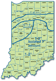
Snowfall Prediction for Indiana Monday afternoon- Tuesday Morning


There will be a small 2-3" band that moves over our area. A rain snow mix is possible for far southern Indiana and less than an inch of snow can be expected for far northern Indiana where the least amount of moisture will be.

Thursday, February 9, 2012

Snow Tomorrow??

Friday will start with clouds (a few flurries) and temps in the mid 20s. Winds will be from the S transitioning from the N after the passage of a cold front. Winds will be 10-15mph with gusts to 25mph during the day. Snow will begin to fly as early as mid morning. Heavier snow will fall in the afternoon. Temps will max out in the mid 30s. Snow will continue through the night and into Saturday morning. Winds overnight will pick up from 10-15mph to 20-25mph gusting to 40mph. This will promote blowing and drifting snow through the evening. Travel may be hazardous Saturday morning.

Now for the snow amounts............
This map looks good with the exception of the far northern Indiana 1-2" amounts. I don't think it will totally cross the state West to East, but I am confident in it at least going halfway to places like South Bend and Goshen.

Wednesday, February 8, 2012

Thursday Forecast

Clouds will diminish with time tonight allowing the temp to fall quickly.

Thursday:Mostly Sunny skies will be with us for tomorrow. Clear skies overnight will allow for temps to be in the low 20s for tomorrow morning. Temps will rise in the afternoon, maxing out near 40º. Winds will be from the WSW at 10-15mph with gusts up to 25mph. Skies will be mostly clear at night fall with temps dropping into the low-mid 20s.

Tuesday, February 7, 2012

Snow Potential

Snow accumulations for the most part will be below 1". I believe the Attica area will see between .1"-.5" of snow with an isolated 1" amount possible. Places in southern Indiana have a better shot at seeing 1" of snow.  For the people going to school, watch out for slick spots. Chance for a 2 hr. delay is between 20% and 30%.

Wednesday Forecast: Snow showers/flurries will be around for the morning commute, again watch for slick spots. Temps will hover around 30 in the morning with winds from the NW at 8-13mph and gusting up to 20mph. Temps will rise in the afternoon into the upper 30s. This will allow for the melting of the morning snow. All the snow should be melted by mid afternoon. Clouds will gradually exit overnight. This will allow the temperature to fall in a hurry. Temps will fall into the mid 20s by midnight and the low 20s-upper 10s by Thursday morning.

When will we see another snow maker?

It looks like we will see a decent storm system move in around Valentine's Day. A couple of inches of snow are possible with this storm, but it is still too early to tell at this time. A weaker storm system will move through Friday-Saturday. Accumulations look to be less than 1" at this time. I will update as more model data rolls in.

January 2012 Weather Review

The January 2012 weather review.
Tyler Snider (5 miles SW of Westpoint)


January, 2012


High Low Actual Avg. Precip. Comments
01/01/12 47.8 30.7 39.25 0.04 flurries
01/02/12 30.6 20.3 25.45 0
01/03/12 29.5 11.5 20.5 0
01/04/12 45.9 25.3 35.6 0
01/05/12 51.1 23 37.05 0
01/06/12 57.8 33.3 45.55 0
01/07/12 47.9 27.3 37.6 0
01/08/12 45.4 21.6 33.5 0
01/09/12 50.4 21.7 36.05 0
01/10/12 54.8 25.3 40.05 0
01/11/12 44.4 30 37.2 0
01/12/12 36.2 14.7 25.45 0.35 3.5” of snow (precip based on standard 10:1
01/13/12 25.7 11.9 17.8 0
01/14/12 31.2 1.5 16.35 0
01/15/12 34.5 -0.6 16.95 0
01/16/12 56.1 29.3 42.7 0.04
01/17/12 57.2 24.2 40.7 1.24 thunderstorms/ small hail
01/18/12 30.2 13.8 22 0
01/19/12 30 1.4 15.7 0.3 3” of snow
01/20/12 21.4 -1.8 9.8 0 Snow overnight
01/21/12 28.4 14 21.2 0.25 2.5” of snow (early morning)
01/22/12 44.7 17.6 31.15 0.25 thunderstorms
01/23/12 50 33.4 41.7 0.58 windy
01/24/12 39.3 24.4 31.85 0
01/25/12 34.3 22.7 28.5 0.05
01/26/12 36.3 32.7 34.5 0.94
01/27/12 45.2 33.3 39.25 0.01 .2” snow/sleet accumulation
01/28/12 39.1 30 34.55 0.02
01/29/12 39.3 21.4 30.35 0
01/30/12 57.3 22 39.65 0
01/31/12 61 45 53 0

42.03 21.31 31.64 4.07 Days above 50: 9 Days below 0: 2
Normal 33.1 16.45 24.775 1.86 Total snow accumulation for the season: 13”
Departure 8.93 4.86 6.865 2.21


January 2012 started dry (for the most part) with sunny days and highs in the mid-upper 50s. This all changed when our first "snow storm" of 2012 rolled in on the 12th. This brought 3.5" of snow to our area doubling our season total at the time. Our first night below 0 (15th) was recorded a few days after this storm as there was a little snow pack left on the ground at the time. Thunderstorms rolled through with small hail early on the morning of the 17th. This brought a few tornadoes to southern Indiana and northern Kentucky. There were 16 reported tornadoes that day with 6 reports in Indiana. We also received 1.28" of rain on the 17th which helped the Wabash rise to flood stage. 19-23rd saw a pretty active pattern. The 19th saw 3" of snow then the following evening saw 2.5" of snow. This has been the most snow in a 60hr. period so far. Temps bottomed out at -1.8 after the 3" snow. The snow pack allowed the temps to fall below 0 for the second time this winter. Warmer temps on the 22nd allowed for a severe weather outbreak just south of our area. A total of 45 tornadoes were reported on the 22nd. 21 reports were from Alabama with 17 reports out of Arkansas. Another storm system made its way in on the 26th with nearly an inch of rain. This again helped the Wabash flow outside of its banks. A minor snow/sleet event happened on the morning of the 27th with .2" of snow and sleet accumulation. Sunny and warmer temps ended the month with a high of 61. The warm temps and sunny skies would continue into early February.

New Info on snow potential shortly!!

Monday, February 6, 2012

7 Day Forecast Feb. 7-13

I am going to start my 7 day forecasts again.

Low Clouds are Holding On

These low clouds are keeping our temperatures down today. The current temps here are in the mid 30s. If you go to Indianapolis, the temperature is right around 50º.

You can see the cloud deck over Northwestern Indiana and Illinois. You can see the snow from the last storm in Iowa and Nebraska.

Tuesday Forecast: Skies will be partly cloudy to start the day. Temps will start the day in the mid20s. Given moist conditions near the surface, fog looks likely. Visibility may be less than .25 mile at times. Fog is projected to last until 11 tomorrow morning. Temperatures will max out near 40º. This temp depends on how early the fog can burn off. The quicker the fog burns off, the higher the temp will be. Winds will be light through the day, but they will pick up after nightfall. Temps overnight will be in the low-mid 30s. More clouds will move in overnight with a few flurries late Tuesday night. Snow accumulations look light with less than 1" of snow.

Note: This is my 100th blog post. It is hard to believe I have already done 100 blog posts. I will continue to update my blog for the Attica/Lafayette area even when I go to college in Oklahoma.

I hope to get a 7 day forecast up later today... it has been awhile since I have done one.

Sunday, February 5, 2012

Superbowl Forecast

Well above normal temps today led to a high of 51 here at the house.

Superbowl: Temps will be right around 40 for kickoff (about 6:30). Skies will be mostly clear tonight with a few low clouds around. Temps will be in the low 30s by the end of the game. Winds will be light and variable at 5mph.

Friday, February 3, 2012

Saturday Forecast

Showers will begin late tonight early tomorrow morning.

Saturday: Temps will start the day in the upper 30s to near 40. Rain will be around all day with a possible break in the rain n the afternoon. Before more rain moves in near sun down. Temps will remain steady in the afternoon in the low-mid 40s. After sun down temps will fall into the upper 30s. It will be cold rain for the overnight. A changeover to snow is possible late tomorrow night. Accumulations up to .5" of snow are possible Saturday night-Sunday morning.

The Superbowl looks decent with partly cloudy skies and temps in the mid 40s. Given the latest trends, I wouldn't be surprised if we break 50º Sunday, but for right now, mid40s are sufficient.

Wednesday, February 1, 2012

Thursday Forecast

Warm Spring-like temps will continue tomorrow.

Thursday: Temps will be in the low 30s tomorrow morning which will promote patchy frost development. Partly Cloudy skies will be the rule tomorrow. Temps will max out at in the mid 50s. Winds will be light at 5-10mph and variable. As night falls, a few more high clouds will move in. I will keep the partly cloudy wording for the evening hours. Temps will be in the low-mid 40s overnight.

Snow??? Accumulating snow is now looking less likely for this weekend. Right now, snow accumulations look to be less than an inch. I will post changes to this forecast when and if necessary. I figure I will have a good idea on snow totals by tomorrow or Friday.

Tuesday, January 31, 2012

Wednesday Forecast.....Snow???

A High of 61 was achieved today here at the station. A perfect way to end January!!

Wednesday: The first day of February will start decent with temps in the upper 30s to near 40. Skies will be partly cloudy all day with a high temp reaching into the low-mid 50s. Winds will be fairly calm at 3-8mph. As night falls a few more mid-upper level clouds will roll in. Temps will drop into the mid-upper 30s.

Snow???- After hitting 61º today, it is hard to believe we are talking about snow chances, but it is Indiana. Snow looks like a good bet for this weekend. How much you ask, well it is still too early to tell. The models are all over the place with snow totals. Some models suggest no snow and others want to give us up to 4". I will update on snowfall totals as the data become more consistent.