A system late next week will bring warmer temperatures, rain, and storms? Storms in December are somewhat common for our area. Here's the setup.
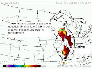
Thursday: A low pressure will be well off to our west and northwest. As the low goes through Iowa and Wisconsin, a warm front will rise over our area. This will make our temperatures rise into the 50s (possibly 60) with low-mid 60s for Evansville. The warm front will bring in higher dew points (40s to near 50) and promote strong wind fields(wind shear) in our area. The instability is also forecast to be a little over 100J/Kg. All these ingredients are right for some flashes of lightning. The only problem with this setup is the CINH or cape inhibition. This can equalize the instability in the atmosphere. The term cap derives from CINH. On a hot summer day, CAPE will skyrocket into the 5000-6000J/Kg, but if you have a CINH of 100-200, it will make a "cap" in the atmosphere reducing the chances for thunderstorms. If storms can break the "cap" then thunderstorms will explode and rise rapidly. There is a little CINH around, but it is hard to tell if it will be enough to put a "cap" on thunderstorm development. If a small amount of CINH moves in, thunderstorm development won't happen. It will just be a flooding rain event.
Weather System
CAPE
CINH
Next Friday: Behind this front, colder weather will move in with temps in the 20s and 30s. If the cold can come in fast enough, a chance of snow will be possible with the left over precip. with this weather system.
As for today-tonight: Expect flurries to be around all day with little to no accumulation. Temps will max out in the mid 30s. This evening will be the coldest of the season (so far) as temps fall into low-mid 10s.


No comments:
Post a Comment