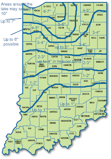
This will potentially be the biggest snowfall so far this season... here is a look at my snowfall prediction.
10" may happen to the north given some lake enhancement. The models keep giving us more and more snow for the area. I am going to stay with 2-3" for the Attica area. Don't be surprised if there is 4" on the ground by Friday morning.
Thursday: Tomorrow will start with the possibility of a few flurries. Temps will be in the low 30s. Temps will fall through the entire day. Snow is expected to arrive sometime between 8-10a.m. Snow will be heavy at times through the day. By the time school lets out (assuming we get out normal time) there should be about an inch on the ground. As night falls, snow will continue. Winds will pick up overnight. Winds will be from the WNW at 20-25mph with gusts up to 40mph. This will cause the snow to blow and drift around. With 2-4" of snow, drifts up to 1-1.5' are likely. Also, with temps in the upper teens to low 20s and with gusts as high as 40mph, wind chills as low as -5 are likely. Friday morning will be rough for commuting.

No comments:
Post a Comment